Winter Storm WARNING Friday - Saturday, Jan 28 - 29


bub said:
Max is great and our modern weather forecasting tech is very impressive but I've long felt that this day to day hovering over projected bad weather has made us neurotic about it. On balance, my recollection is that at least with snow, the results over the years have tended to be milder than forecast. And when it isn't, so what? It gets shoveled just like it did in the past when we did not have as much high tech long term info.
I like being able to plan for inclement weather.
If I know something is coming, I try to stay off the roads, and advocate for work from home. And I put the car in the garage. And try to anticipate whether to organize a carpool to get the kids to some activities, or expect cancellation. Make sure the shovels are in the house and not in the back shed. Find the sleds, etc.

yahooyahoo said:
I found this interesting as a layperson in regards to weather forecasting.
"Many of us see weather forecasts and hear the terms “European models” and “American models” within them. But do we know what the difference is between these models and what they both mean? The main differences between the two models involve accuracy and time frame of predictions; however, both are global models."
One is in celsius and the other in fahrenheit

max_weisenfeld said:
yahooyahoo said:
I found this interesting as a layperson in regards to weather forecasting.
"Many of us see weather forecasts and hear the terms “European models” and “American models” within them. But do we know what the difference is between these models and what they both mean? The main differences between the two models involve accuracy and time frame of predictions; however, both are global models."
One is in celsius and the other in fahrenheit
wait, what? U.S. scientists are still using Fahrenheit?

And there are more than two models. The American system alone has over a dozen, global and mesoscale models. Besides the Euro, Germany, the UK, Canada, China, and Australia run global models, although they are generally not a accurate in the western hemisphere as the GFS and Euro.
ml1 said:
max_weisenfeld said:
yahooyahoo said:
I found this interesting as a layperson in regards to weather forecasting.
"Many of us see weather forecasts and hear the terms “European models” and “American models” within them. But do we know what the difference is between these models and what they both mean? The main differences between the two models involve accuracy and time frame of predictions; however, both are global models."
One is in celsius and the other in fahrenheit
wait, what? U.S. scientists are still using Fahrenheit?
No, that was meant as a joke.
They don't even use American time. All the models are on Universal time
max_weisenfeld said:
ml1 said:
max_weisenfeld said:
yahooyahoo said:
I found this interesting as a layperson in regards to weather forecasting.
"Many of us see weather forecasts and hear the terms “European models” and “American models” within them. But do we know what the difference is between these models and what they both mean? The main differences between the two models involve accuracy and time frame of predictions; however, both are global models."
One is in celsius and the other in fahrenheit
wait, what? U.S. scientists are still using Fahrenheit?
No, that was meant as a joke.
They don't even use American time. All the models are on Universal time
I thought it was a joke. And my response was a joke.
we need to use the jokey emojis 

some posters said we would have a blizzard. A blizzard has nothing to do with the amount of snowfall but other conditions:
What is a blizzard???
A violent snowstorm with winds blowing at a minimum speed of 35 miles
per hour and visibility of less than one-quarter mile
for three hours.
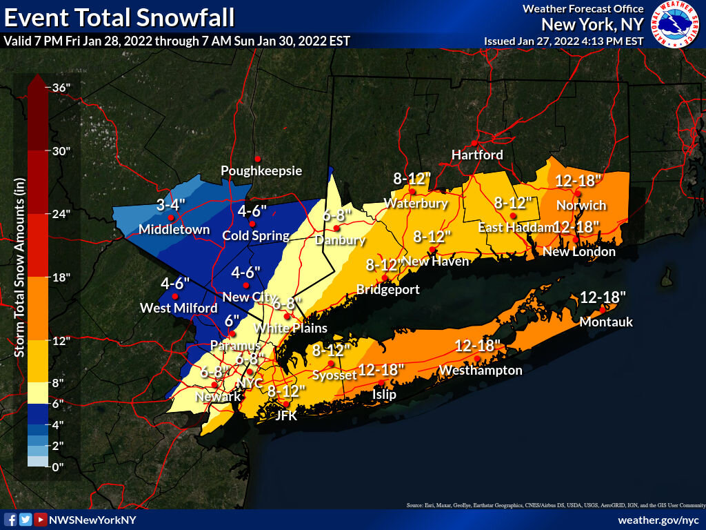
Right now there are numerous snowfall forecasts for our Maplewood area: Weather Channel 3", NWS 5-7, Accuweather 4-8, CBS 2-6"!!!
Days in advance of the blizzard of March 13, 1993 the European model correctly predicted the geographic size and intensity of this storm days in advance . They were right on the money while our various American models including our NWS, Accuweather and the weather channel did not agree until the storm was on it's way!
Here in Maplewood, we had 20"+ with drifts many feet high. Our DPW had to use pay loaders and dump trucks to pile up the snow in Memorial and Maplecrest Parks. Snow on Maplewood Ave in Maplewood Village was plowed right up to the storefronts in many places because the sidewalks are so narrow. Business owners had to wait for DPW to remove the snow that the could open up!
Perhaps Jamie may recall this.
Thursday Evening Jan 27
I keep thinking, one more model run and I'll have this one figured out. But no....
Ok, so here's my best shot at this moment.
The NWS has us under a Winter Storm Watch. I am thinking we are looking at 5 - 8" with both upside and downside potential. Snow showers during the day Friday will not accumulate. The real show starts between 7 and 9pm, with snow getting heavy after midnight. Snow likely to continue through most of Saturday morning and could continue into the afternoon.
Winds pick up Saturday early morning and by midday could be steady in the 25 - 30mph range with gusts up to 40mph.
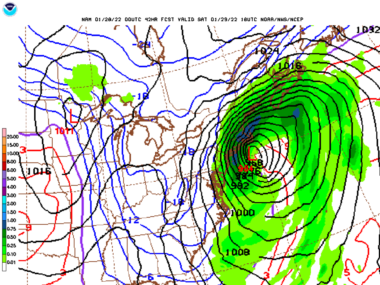
I'm seeing a possible trend in the models to a stronger storm closer to the coast, so I expanded the high end. The NWS extended the Winter Storm Watch west from the earlier watches this afternoon based mostly on the Euro. Since then, the GFS has shifted west as well, and the last run of the NAM, an American model, shifted strongly west. The NAM is a higher resolution model with a shorter range, it is just coming into it's accurate range with this run. All the models have a strong storm off the coast with a lot of snow in its northwestern quarter.
flatbush said:
some posters said we would have a blizzard. A blizzard has nothing to do with the amount of snowfall but other conditions:
What is a blizzard???
A violent snowstorm with winds blowing at a minimum speed of 35 miles
per hour and visibility of less than one-quarter mile
for three hours.Right now there are numerous snowfall forecasts for our Maplewood area: Weather Channel 3", NWS 5-7, Accuweather 4-8, CBS 2-6"!!!
Days in advance of the blizzard of March 13, 1993 the European model correctly predicted the geographic size and intensity of this storm days in advance . They were right on the money while our various American models including our NWS, Accuweather and the weather channel did not agree until the storm was on it's way!
Here in Maplewood, we had 20"+ with drifts many feet high. Our DPW had to use pay loaders and dump trucks to pile up the snow in Memorial and Maplecrest Parks. Snow on Maplewood Ave in Maplewood Village was plowed right up to the storefronts in many places because the sidewalks are so narrow. Business owners had to wait for DPW to remove the snow that the could open up!
Perhaps Jamie may recall this.
It is highly unlikely we will have blizzard conditions here, although the components of heavy snow and high winds are possible. It is much more likely that such conditions could occur on Eastern Long Island with this storm.
With this storm, since the main global models have not been entirely consistent with their output, no one model is going to be able to claim 'victory.' Earlier this season, the GFS did a better job with our first two winter weather periods. This time, I think the Euro is more likely closer. Overall, the Euro tends to be somewhat better as it is a more advanced and higher resolution model, but both models, and the other, shorter range and specialty models the complement them, are regularly updated and improved, and on the whole are much better than anything we had in the 90s. The bottom line is that the models propose solutions but it takes skilled meteorologists (of which I am not one) to interpret the data and actually make a forecast. That is to say, models don't forecast. Scientist use models as tools to make forecasts.
Friday morning, Jan 28
Confidence is growing in a widespread major winter storm, with the MAPSO area on the western edge. The NWS has upgraded all Watches to Winter Weather Warnings ⚠️ as we get closer to show time. The models continued to narrow their spread and the consensus shifted slightly west overnight.
Continue to expect 5 - 8 inches with bias towards the higher end of the forecast at this moment. There are still upside and downside contingencies but they are narrowing.
In addition, have fairly high confidence in winds on Sat in the 20s with possible 40mph gusts that could reduce visibility and make driving even more difficult. Travelers should be aware that south, east, and north of us will be getting substantially more snow, with widespread areas of 12 to 18 inches likely, and travel on Sat out of the area is not advised.
Timing will be affected to some extent by any continued shift in track. For now, expect possible light snow today during the day of little or no consequence. Tonight, snow possibly starting after 8 pm and likely becoming steady after midnight. Steady snow should continue through tomorrow morning and may continue into the afternoon for a couple of hours. Lighter snow possible into early evening as the storm moves off.
Winds likely to pick up in the early hours Sat and likely to reach their peak midday. With the cold air in place the snow will be light and blowing and drifting is possible.
Travel will be very difficult on Saturday. Plan to stay home.
Sunday and Monday will continue quite cold.
From the NWS:
Winter Storm Warning
URGENT - WINTER WEATHER MESSAGE
National Weather Service New York NY
EST Fri Jan 28 2022
...WINTER STORM WARNING IN EFFECT FROM 7 PM THIS EVENING TO 7 PM EST SATURDAY...
* WHAT...Heavy snow expected. Total snow accumulations of 4 to 7 inches. Winds gusting as high as 40 mph.
* WHERE...Portions of northeast New Jersey and southeast New York.
* WHEN...From 7 PM this evening to 7 PM EST Saturday.
* IMPACTS...Travel will become be very difficult.
PRECAUTIONARY/PREPAREDNESS ACTIONS...
If you must travel, keep an extra flashlight, food, and water in your vehicle in case of an emergency.
Check local Department of Transportation information services for the latest road conditions.


Thank you Max. As always your presentation of the weather facts is invaluable.
I guess I better go buy my snow day bacon. Maybe stop at Sonny's today.

This is a little to the North posted by my buddy From CT who’s a weather geek. Very clear what to expect.
Thanks so much for the good localized weather reports. I remember the days when rather than stocking up and hunkering down for large snow, I would cheer and point my car north towards ski country.


Are you sure it wasn't Trump taking out the old sharpie to continue his weather forecasting career?

Jasmo said:
Are you sure it wasn't Trump wasn't taking out the old sharpie to continue his weather forecasting career?
the sharpie was around long before Trump.

Redfruit said:
Jasmo said:
Are you sure it wasn't Trump wasn't taking out the old sharpie to continue his weather forecasting career?
the sharpie was around long before Trump.
I grew up watching Sonny Eliot do the weather on Detroit local TV with chalk on a board ... Not gonna lie, this is where John Madden got his telestrator shtik.

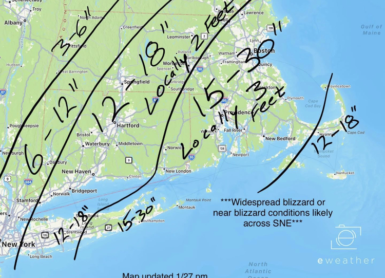
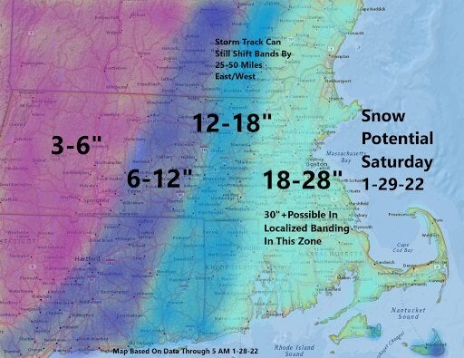
Here's a little better forecast image for the New England area. I recall some truly shocking storms when I lived there.
https://www.boston.com/weather/local-forecasts/2022/01/26/david-epstein-snow-storm-forecast-jan-28-29/
PeterWick said:
Here's a little better forecast image for the New England area. I recall some truly shocking storms when I lived there.
https://www.boston.com/weather/local-forecasts/2022/01/26/david-epstein-snow-storm-forecast-jan-28-29/
this thread is about the local weather, not New England. That image is not helpful.

There are probably few among us who don’t have at least one friend or loved one in CT, MA or ME. Personally, I found it helpful, but that’s me.

Redfruit said:
this thread is about the local weather, not New England. That image is not helpful.
maybe you should change your handle to Sour fruit
Heynj said:
There are probably few among us who don’t have at least one friend or loved one in CT, MA or ME. Personally, I found it helpful, but that’s me.
this weather thread is hyperlocal. The concern is of course someone here thinking there’s 28 inches coming this way.
Redfruit said:
this thread is about the local weather, not New England. That image is not helpful.
Spit take

Redfruit said:
Heynj said:
There are probably few among us who don’t have at least one friend or loved one in CT, MA or ME. Personally, I found it helpful, but that’s me.
this weather thread is hyperlocal. The concern is of course someone here thinking there’s 28 inches coming this way.
didn't you post this image of New England snowfall predictions?

drummerboy said:
Redfruit said:
Heynj said:
There are probably few among us who don’t have at least one friend or loved one in CT, MA or ME. Personally, I found it helpful, but that’s me.
this weather thread is hyperlocal. The concern is of course someone here thinking there’s 28 inches coming this way.
didn't you post this image of New England snowfall predictions?
The bottom of the map was well into the tri-state region. Big difference obviously.
Redfruit said:
The bottom of the map was well into the tri-state region. Big difference obviously.
uh-huh. sure. is hyper-local MAPSO on that map?
Sponsored Business


Promote your business here - Businesses get highlighted throughout the site and you can add a deal.
For Sale


Garage Sales
-

HUGE Rummage sale to benefit the Bloomfield High School Robotics Team Sale Date: Apr 27, 2024
More info

Winter Storm Watch