Winter Weather Advisory for Likely Icing Friday 2/4


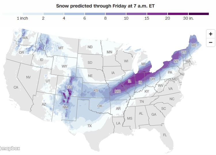
The magnitude of this next storm (2,000 miles long) is pretty amazing. Fortunately, looks like we're again spared he worst of it.

jamie said:
The magnitude of this next storm (2,000 miles long) is pretty amazing. Fortunately, looks like we're again spared he worst of it.
potential for ice from Texas all the way to New York State? Hopefully it doesn’t drift too much to the East coast.

I know it isn't hyper-local to make note of this but my family still living up north of Syracuse is not looking forward to this threat. So what if they've lived up there and should be used to it. It's actually more concise to say that they live up there and know what kind of damage ice and snowstorms like this can do.


To be clear, we are getting this storm. Right now, it looks to be rain with a bit of snow and sleet right at the end here, but this is a very serious threat to a significant portion of the country from tomorrow through Friday.
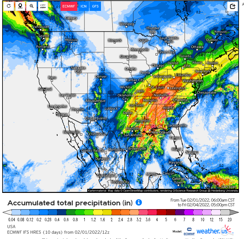
This is the total precipitation map from the Euro for this system from now through Friday
max_weisenfeld said:
This is the total precipitation map from the Euro for this system from now through Friday
An inch of ice for our area? That would be terrible.

Jaytee said:
max_weisenfeld said:
This is the total precipitation map from the Euro for this system from now through Friday
An inch of ice for our area? That would be terrible.
an inch of ice would be a catastrophe, but that's not what the map is saying.

drummerboy said:
an inch of ice would be a catastrophe, but that's not what the map is saying.
ok, gotcha. It’s the total amount of precipitation?
Jaytee said:
drummerboy said:
an inch of ice would be a catastrophe, but that's not what the map is saying.
ok, gotcha. It’s the total amount of precipitation?
yup

drummerboy said:
Jaytee said:
drummerboy said:
an inch of ice would be a catastrophe, but that's not what the map is saying.
ok, gotcha. It’s the total amount of precipitation?
yup
Most of which will be rain
Wed Feb 2 Update
Possibility of a wintery mess with snow, sleet, and ice on Friday increased overnight.
Late yesterday and overnight, the modeling trended generally colder, although there is still a fairly wide spread and substantial variation. The cold arrives sooner, and averaging together the global models indicates that we might expect light rain Thursday all day and into the night. Sometime after midnight rain becomes steady. Heavier precipitation Friday morning as temps drop could be snow and sleet with freezing rain (ice) mixing in, continuing most of the day. This could interfere with both the morning and evening commute. There is also the possibility that any puddles and liquid standing water will freeze up on Friday at some point. Precipitation looks to end Friday evening.
If this pattern persists expect to start seeing winter storm watches from the NWS as early as this afternoon.
Yet again, doctor appointment early Friday morning. That's 3 so far. Had to cancel one already.

Wasn't Syracuse on the news a few years ago for finally clearing out the last of the snow piles in June?
RobertRoe said:
Wasn't Syracuse on the news a few years ago for finally clearing out the last of the snow piles in June?
I don't recall it going that late but wouldn't be surprised. There were some stretches where they had to truck the snow to places where they could just pile it up and wait for it to melt. They did get pretty big.
Remember that year when Oswego and other places on the eastern shores of Lake Ontario got about 6 feet of snow in a couple of weeks? 2007. Usually that snow belt west of the Tug Hill Plateau has upwards of 100 inches of snow each year what with the lake effect pattern. You see these white collars to the east of the Buffalo and Syracuse areas in TV weather broadcasts and it just makes me shake my head. It seems like it snows there just because it's a Tuesday sometimes. ;-) I don't miss those days.


RobertRoe said:
Wasn't Syracuse on the news a few years ago for finally clearing out the last of the snow piles in June?
I think it was Boston in 2015. Although I'd bet Syracuse has years like that too.
Wednesday evening, 2/2
It is very tempting when faced with a set up like Friday, where the question of, "will there be an ice storm or not," to jump after every new model run (the globals like the GFS and Euro run every 6 hours and come out on a somewhat staggered schedule). I'm going to try not to whipsaw you like that too much.
At this point I will say that there is still a significant spread between the models but I do think some icing is becoming more likely with each run. There is still strong data supporting fairly low accumulation, perhaps mixing with sleet (sleet is crunchy and halfway between snow and ice on the ground and much less likely to accumulate on wires and trees than freezing rain). But even a light glaze of ice in the wrong place can make travel (including walking) quite hazardous.
The NWS, both the New York Office and the National Weather Prediction Center, still do not forecast to be a warning-level ice event, which is somewhat reassuring. Timing is still Friday through the day and early evening. This could narrow significantly in the next 24 hours as we get closer and the short-range models come into play.
Next update in the morning.
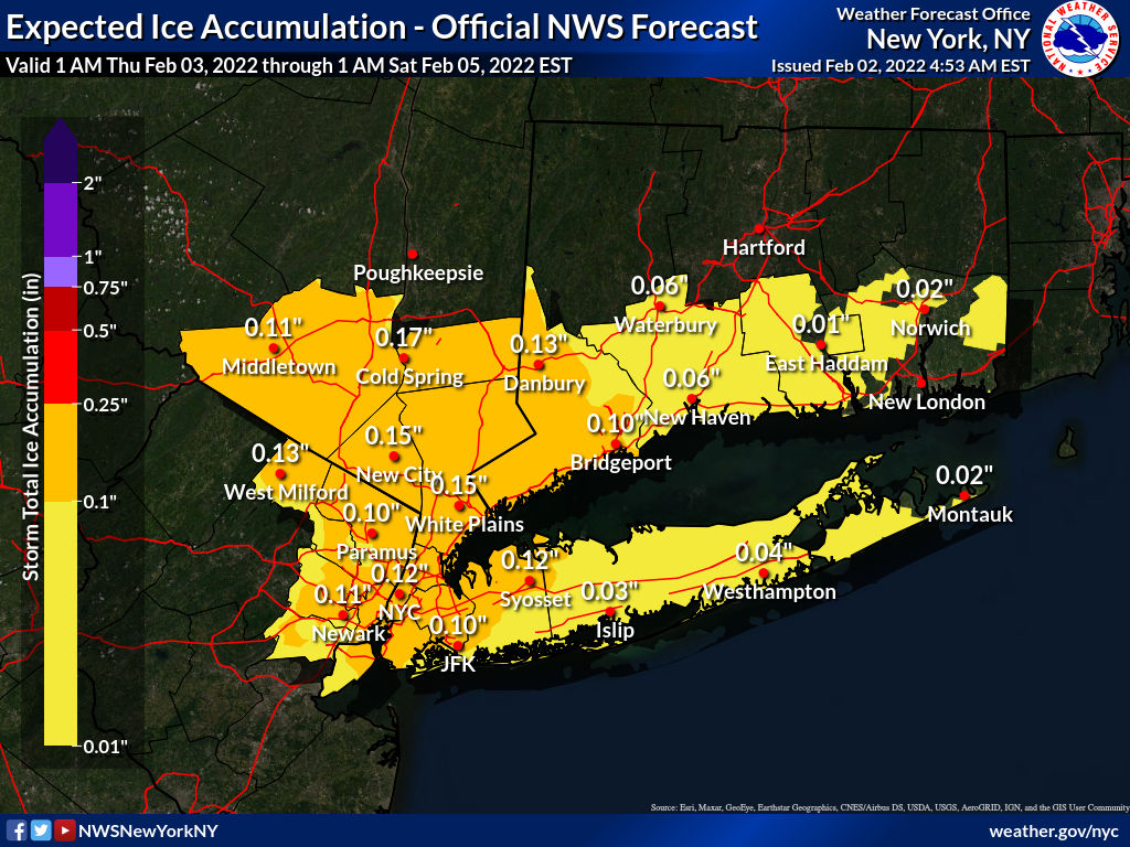
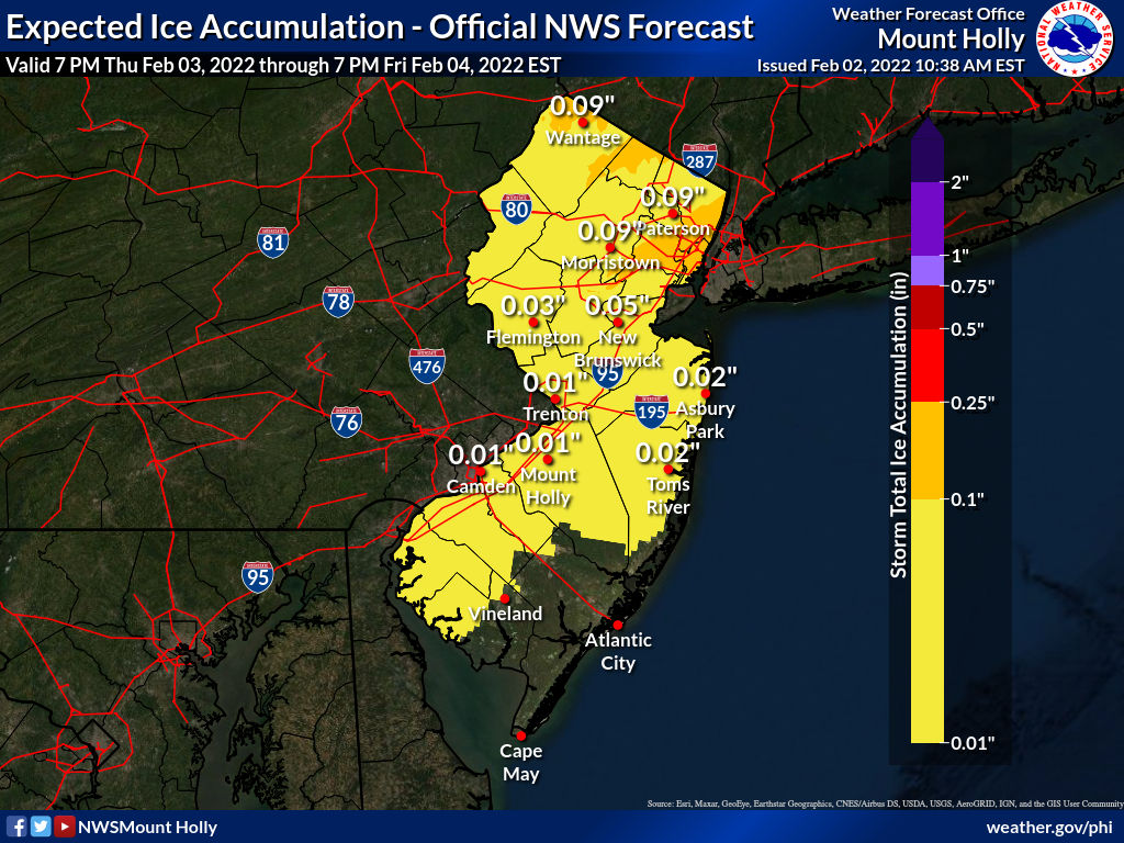
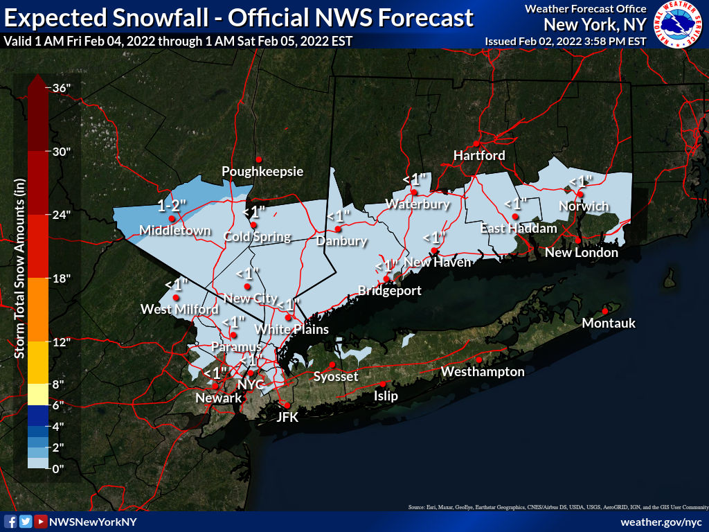
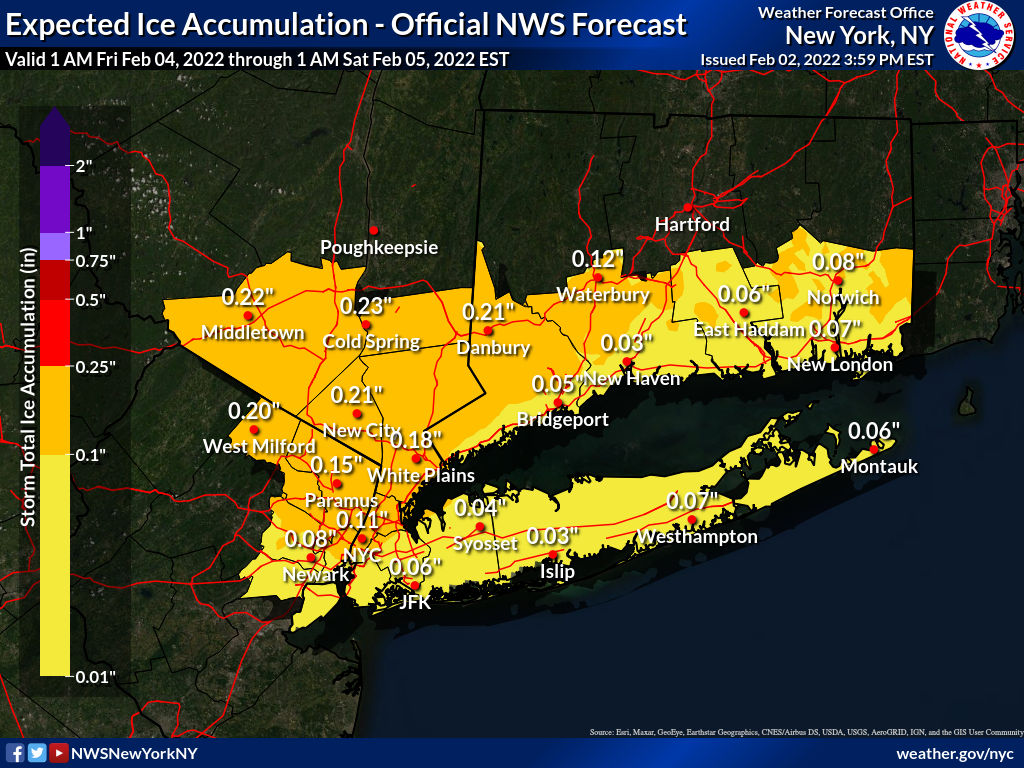
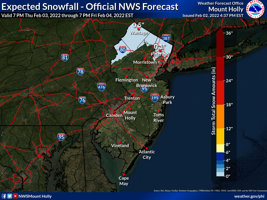
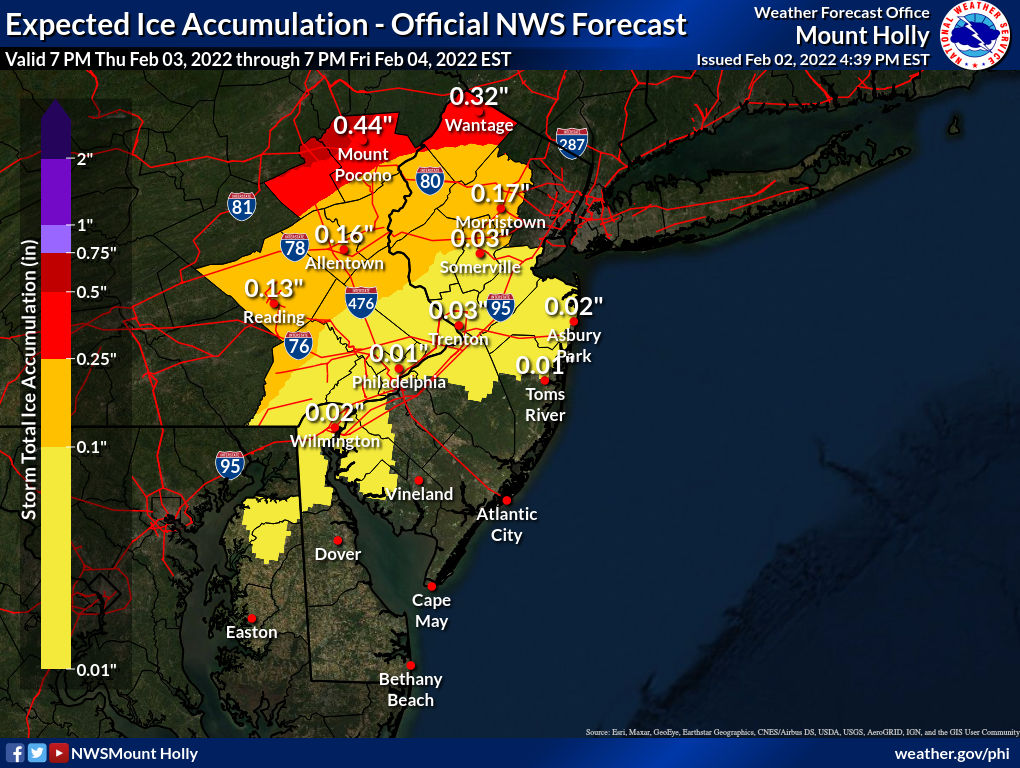
Here are updated ice and snow maps for north and south Jersey:.

Max,
Snow is a 4 letter word, go wash out your mouth with soap.
Ice is a 3 letter word, which is even worse. This is your final warning.
Thurs morning Feb 3 update
Most models are slowly backing off from the worst case scenarios but some icing remains in the forecast this morning.
Today, light rain overspreads the area this morning, continuing as liquid rain all day and into the night.
Overnight, temps will rise, getting into the mid 40s before starting to fall very early Friday morning. Rain continues.
Friday during the morning rain continues, likely at some point after daybreak mixing with some form of frozen precipitation, either snow, sleet, or freezing rain, or some mixture of the three over the course of the day. At this time, the NWS has MAPSO on the southern edge of the area of possible ice accumulation, with more significant icing more likely north into Upstate NY and far northeast PA. Here, a glaze of ice may occur, possibly happening more than once, then melting, then freezing again before the rain stops. Expect a hard freeze of any standing water overnight Friday. Saturday clearer.
At this time I do not expect this to be a major ice storm here, but a glaze of ice may at times Friday make travel difficult.
Winter Weather Advisory
URGENT - WINTER WEATHER MESSAGE
National Weather Service New York NY
356 AM EST Thu Feb 3 2022

NJZ004-103>106-NYZ069>071-032130-
/O.NEW.KOKX.WW.Y.0008.220204T1100Z-220204T2300Z/
Eastern Passaic-Western Bergen-Eastern Bergen-Western Essex-
Eastern Essex-Rockland-Northern Westchester-Southern Westchester-
356 AM EST Thu Feb 3 2022

...WINTER WEATHER ADVISORY IN EFFECT FROM 6 AM TO 6 PM EST
FRIDAY...

* WHAT...Mixed precipitation expected. Total snow accumulations
  of up to one inch and ice accumulations of up to two tenths of
  an inch.

* WHERE...Portions of northeast New Jersey and southeast New
  York.

* WHEN...From 6 AM to 6 PM EST Friday.

* IMPACTS...Plan on slippery road conditions. The hazardous
  conditions could impact the Friday morning commute.

PRECAUTIONARY/PREPAREDNESS ACTIONS...

Slow down and use caution while traveling.

Check local Department of Transportation information services for
the latest road conditions.

Was once speaking to PSE&G Exec who said their biggest nightmare is a huge ice storm, even more than a hurricane, as it could bring down major trunk lines and would cut off heat to thousands of customers in the middle of winter and it’s hard to fix the lines until the ice thaws. Hopefully we’ve dodged that bullet - at least for now.
I don’t remember the exact year, sometime in the mid 90’s, when we had a really bad ice event. Stuck on 78 going to Newark, I had to exit at the Bergen avenue exit. Could not get back on 78 west, decided to pick up Springfield avenue to get back to maplewood. That’s one experience I would not wish to experience ever again. Buses on Springfield avenue were just sliding into light poles and parked cars. Accidents everywhere. 5 hours later I crawled into my driveway.
Thursday Evening Update, 2/3/22
Forecast remains on track for a chance of freezing rain tomorrow, especially from 10 - 2pm, but the chance exists most of the day.
The unfortunate bottom line is that, while it is continuing to be unlikely that we will get a full-fledged ice storm here, periods of freezing rain could mix in with rain, snow, and sleet tomorrow as temps drop and the rain ends. It will come down to whether the cold noses in before the rain ends. Note that light rain at the end of the precipitation period could make icing more likely (small drops freeze faster) so that is one of the things to watch for.
Travel will be affected on multiple levels, with airlines dealing with the entire storm as it has and is sweeping across the country, and a significantly greater icing risk west and especially north of us which could affect trains and make travel out of the area even more difficult than here.
Winter Weather Advisory still in effect
Friday morning, Feb 4
Forecast on track for rain changing over to mixed precipitation, including snow, sleet, and freezing rain. There is a Winter Weather Advisory in effect.
As a cold front moves through the area from West to east this morning temperatures, currently in the 50s, will drop precipitously through the 40s and 30s. As the tempurature near the ground drops, precipitation will continue, becoming lighter as the day progresses. While a severe ice storm is not expected, a glaze of ice is likely to form on untreated surfaces and standing water will freeze. Sometimes rain will wash the treatment off roads, so even diligently pre-treated roads can become slick and dangerous. Proceed with caution, especially this afternoon and early evening.
Timing: expect changing conditions from 10am until at least 7 or 8pm.
A couple of notes. In these conditions, light rain or drizzle is the most likely to freeze. The smaller droplets release heat quicker.
Don't trust your app for tempurature today. Your app tells you the temp at Newark Airport. Usually that is good enough, but at some point today as the front moves through there will very possibly be a difference of 5 - 10 degrees between here an the airport, with here being colder. As I write this, there is a 15 degree difference between here and Sparta in Sussex County, which is behind the cold front.
From the NWS:
Winter Weather Advisory
URGENT - WINTER WEATHER MESSAGE
National Weather Service New York NY
403 AM EST Fri Feb 4 2022
NJZ004-103>106-NYZ069>071-050000-
/O.CON.KOKX.WW.Y.0008.220204T1100Z-220205T0000Z/
Eastern Passaic-Western Bergen-Eastern Bergen-Western Essex-
Eastern Essex-Rockland-Northern Westchester-Southern Westchester-
403 AM EST Fri Feb 4 2022
...WINTER WEATHER ADVISORY REMAINS IN EFFECT UNTIL 7 PM EST THIS
EVENING...
* WHAT...Mixed precipitation expected. Total snow accumulations
of under an inch and ice accumulations of one tenth to two
tenths of an inch.
* WHERE...Portions of northeast New Jersey and southeast New
York.
* WHEN...From 6 AM to 7 PM EST Friday.
* IMPACTS...Plan on slippery road conditions. The hazardous
conditions could impact the morning and evening commute.
PRECAUTIONARY/PREPAREDNESS ACTIONS...
Slow down and use caution while traveling.
Check local Department of Transportation information services for
the latest road conditions.

Are we still on the southern edge of this storm? What conditions should we expect for traveling to the Shore?

From the radar on Weather Channel app, going to the shore should be ok. Just rain.
Rentals

Sponsored Business


Promote your business here - Businesses get highlighted throughout the site and you can add a deal.

Tuesday Feb 1st
I was going to hold off on posting but it appears the commercial forecasters are hyping the rain on Friday as an ice storm and people are getting justifiably concerned.
At this time, there is only one model showing significant icing, so while the possibility exists, I would prefer to wait 24 hours and see a few more runs to see if we can get some agreement on what form the precipitation is going to take.
Ice storms are devilishly hard to predict as they take three things being aligned perfectly (or if you prefer, massively poorly) to occur. You need precipitation, which will almost certainly happen. You need warm air aloft (at roughly 5000 feet) to melt the precipitation to rain -- we will have that, too. And you need very cold air in the last 30 feet (or very frozen ground) to re-freeze the rain. I don't think, at this time, the lower level will be cold enough to freeze the rain until after the rain stops.
But the usual caveats apply: it is still over three days out, and the narrow band in which frozen rain could occur is moving on every model and between every run. Things could change.
tl:dr There is a chance of freezing rain on Friday during the day causing icing. At this time both the NWS and I would prefer to say it is a slight chance. We shall see.